One of just a few books on the subject, Mosaic of Winnipeg Street Names, by Jaroslav Bohdan Rudnyckyj, was published by the Canadian Institute of Onomastic Sciences (now the Canadian Society for the Study of Names) in 1974, as a way of marking Winnipeg’s centennial year. Rudnyckyj was a Canadian linguist whose speciality was etymology and onomastics (or onomatology; the study of names). While Mosaic of Winnipeg Street Names, which inspired this post, contains the history and explanations behind many street names in Winnipeg, this post will go beyond that; it will also consider statistical and geographical properties of streets.
In keeping with the previous Winnipeg Trivia post, some of the questions that have come to mind are the extremes – the shortest and longest street names, the shortest and longest streets, the most valuable street. Some questions depart from that theme, of course. There are any number of questions that can be considered, but I have again limited myself to a fairly standard ten items.
As with the previous post, one of the obstacles of determining these kinds of facts is having adequate data. Thankfully, again, the City of Winnipeg has created an Open Data Portal (data.winnipeg.ca) which provides sufficient data for producing answers.
The data used to arrive at the ten facts below is from the road network (City of Winnipeg, 2020a) and assessment parcel (City of Winnipeg, 2020b) datasets. Given that these datasets are updated every so often, it should be noted that the road network and assessment parcel datasets I used were downloaded on April 12, 2020.
Longest street name
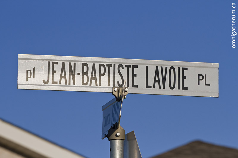
Jean-Baptiste Lavoie Place, the longest street name in Winnipeg.
The longest street name in Winnipeg is Jean-Baptiste Lavoie Place, in the Maginot neighbourhood, at 20 characters long excluding the street type. Dr. Michael K. Grace Way, in the Peguis neighbourhood, is also 20 characters long without the street type. However, including the street type in the length calculation allows for the tie to be broken (26 characters versus 24 characters, including spaces). According to the City of Winnipeg’s Planning, Property & Development document on street naming (2018a, para. 8): “street names should not generally exceed 20 characters in length, including spaces between words, but not including cardinal direction letters and abbreviations for street types.”
In contrast, the longest street name in the world is possibly Dwudziestego Pierwszego Praskiego Pułku Piechoty imienia Dzieci Warszawy, in Warsaw, Poland, at 72 characters long, including spaces (Mason, 2005; Portal Płock, 2017). The approximate translation from Polish is “Twenty First Prague Infantry Regiment named after Children of Warsaw.” That said, the street appears on Google Maps as “21 Pułku Piechoty Dzieci Warszawy”.
Shortest street name
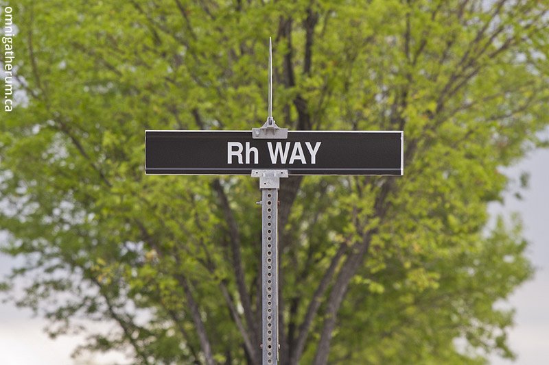
Rh Way, the shortest street name in Winnipeg.
The shortest street name in Winnipeg is Rh Way, at the University of Manitoba, at 2 characters long excluding the street type. It’s also the only street with two letters in its name. Rh Way is named for the research conducted by Bert Friesen, which was directed towards eliminating Rh disease, where blood Rh factors differ between a mother and her baby (Davies, 2019).
The shortest street name in the world is technically 0 characters, and belongs to any number of streets lacking official names. A good example of that would be streets in Arctic communities in Canada, such as Sanikiluaq (CBC News, 2015, para. 2). The next shortest would be a single character. There are a number of examples worldwide, but a notable one would be several streets in Washington, D.C., USA. Washington, D.C. uses an alphabet system (though, skipping some letters) for its east-west streets (Johnson, 2009) – for example, K Street.
Longest street
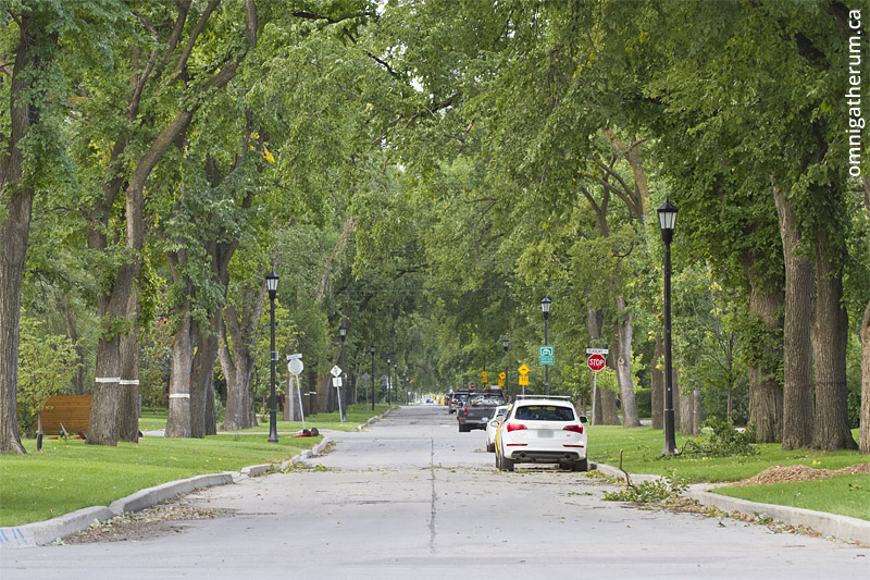
Waverley Street, the longest non-contiguous street in Winnipeg.
This depends on what is considered a street. Under consideration are streets that are entirely within city limits, maintained by the city, and without name changes (e.g. Grant Avenue to Roblin Boulevard).
The portion of the Perimeter Highway (Provincial Trunk Highways (PTH) 100 and 101) within city limits is the longest non-contiguous length of road in the dataset. However, it is not maintained by the City of Winnipeg, but rather Manitoba Infrastructure. It is also not entirely within city limits. The longest non-contiguous street maintained by the City, and entirely within city limits, is Waverly Street at 18,455 meters long. The longest contiguous street maintained by the City, and entirely within city limits, is Lagimodiere Boulevard at 18,279 meters long.
For several years, the Guinness Book of World Records listed Yonge Street, in Toronto, Ontario, Canada, as being the longest street in the world, at 1,896,290 meters (Young, 1998, p. 81). In 1999, however, this record was removed (Perra, 2011, para. 3). In reality, the portion of Yonge Street within Toronto city limits is 17,811 meters long. Other claims as to the longest street in the world include Western Avenue, in Chicago, Illinois, USA, at 38,463 meters long (e.g. Leroux & Reardon, 2008).
Shortest street
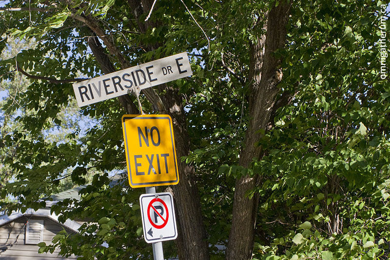
Riverside Drive East, the shortest street in Winnipeg.
This again depends on what is considered a street. The streets under consideration are entirely inside city limits and are maintained by the City. Streets that do not have an exit (i.e. only one inlet or outlet) are included. In the dataset, cul-de-sacs are represented by a single line (as opposed to a loop, particularly in the case of those with central ‘islands’). This tends to under-measure the length of the street. Streets that are cul-de-sacs (denoted by e.g. “Court”, “Place”, “Cove”) were re-measured as loops.
The shortest street is Riverside Drive East, in the Point Road neighbourhood (Fort Garry), at 36.06 meters. A close second is Habitat Place in the Lord Selkirk Park neighbourhood (Point Douglas), at 38 meters.
The shortest street without addresses is Wood Street, in the Osborne Village neighbourhood, at 41.55 meters. (The street signs for Bell Ave and Wood St appear to be switched, going by the dataset.) A close second is Behnke Road in the Worthington neighbourhood (St. Vital), at 41.8 meters. The dataset reports the length as 21.95 meters, though the paved area is quite a bit longer than that.
There is another short street in the dataset that lacks addresses: Moody Street. However, it does not, strictly speaking, exist. It was amongst a number of streets created in 1907, in preparation for a housing development but, as a City of Winnipeg Rights-of-Way Closing (DAC) application notes, the “rights-of-way have never been paved or used for any other public purpose” (City of Winnipeg, 2007, p. 7).
In comparison, the shortest street in the world is Ebenezer Place in Wick, Caithness, Scotland, UK, at 2.05 meters (Glenday, 2008, p. 83). Despite its length the street has one address, 1 Ebenezer Place, which is home to a restaurant called No 1 Bistro (BBC News, 2006, para. 2; Reincke, 2013, p. 532).
Single length of road with the most name changes
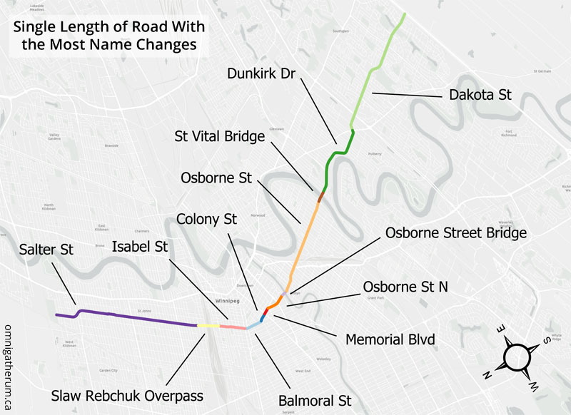
A map of the name changes along the road.
A continuous length of road not broken by any turns that also has the most name changes. Turns are departures from the flow of traffic requiring the use of a turn signal. Lane changes are not counted as turns, but merges are. A simple example of this is the transition from Grant Avenue to Roblin Boulevard. More substantial examples are Riddle Avenue to Denson Place to Wolever Avenue, or Brookside Boulevard to Oak Point Highway to King Edward Street to King Edward Street East to Century Street to Academy Road to Sherbrook Street. The most name changes for a single length of road is the sequence of: Dakota Street, Dunkirk Drive, Osborne Street, Osborne Street North, Memorial Boulevard, Colony Street, Balmoral Street, Isabel Street, Salter Street (for a total of nine names, excluding bridges).
Number of street types
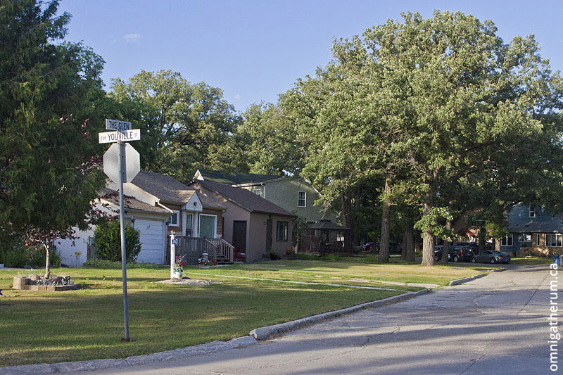
The Glen, one of a number of streets in Winnipeg without a street type.
The Statistics Canada Road Network File Reference Guide lists a total of 170 street types (2019a, pp. 10-14). There are quite a few street types that Winnipeg does not have, though some may be used in the future (e.g. knoll), while others are unlikely to ever be used (e.g. wharf). In total, there are 40 street types currently used in Winnipeg (though, the dataset lists 35). The most common are (unsurprisingly) Street (788), Avenue (758), and Place (528). The least common include Common (1), Freeway (1), Garden (1), Hill (1), Run (1), Cercle (1), Green (1), Meadow (1), Stroll (1), and Mews (1).
There are a number of streets in Winnipeg that do not have a street type. A notable example is Broadway. A webpage of the Manitoba Historical Society notes that Broadway was created in 1873 and was “named by the Hudson’s Bay Company as the primary east-west thoroughfare through its Reserve in Winnipeg” (Goldsborough & Kramer, 2020). Rudnyckyj seems to refer to Broadway as Broadway Avenue (1974, p. 42), as do several maps of Winnipeg in the first half of the 20th century, however, its official name is still simply Broadway. Other streets that do not have a street type include: Sturgeon Access, Wayfarer’s Haven, Blairmore Gardens, Kingsway, The Glen, The Promenade (denoted on signs as “Portage Place Promenade”), or the one-way streets Eastway and Westway. Despite their names, West Gate, Middle Gate, and East Gate (all in Armstrong Point) do not have a street type – both the dataset and the street signs indicate that “Gate” is part of the street name. On the other hand, Appleford Gate is an example of a street that does in fact have a street type of “Gate”.
There are a few streets that the dataset appears to incorrectly label as having no street type – that is, the street sign itself indicates a street type. For example: Cercle Moliere (the street type is “Cercle”), Kinsbourne Green (“Green”), Millwood Meadow (“Meadow”), Southlawn Stroll (“Stroll”), Ruines du Monastere (the street sign has “Rue Des Ruines du Monastere St”), and lastly both Craglea Corner and Crittenden Corner (“Corner”). Interestingly, “Corner” is not listed in the Road Network File Reference Guide (though, “Corners” is).
Total number of streets in Winnipeg
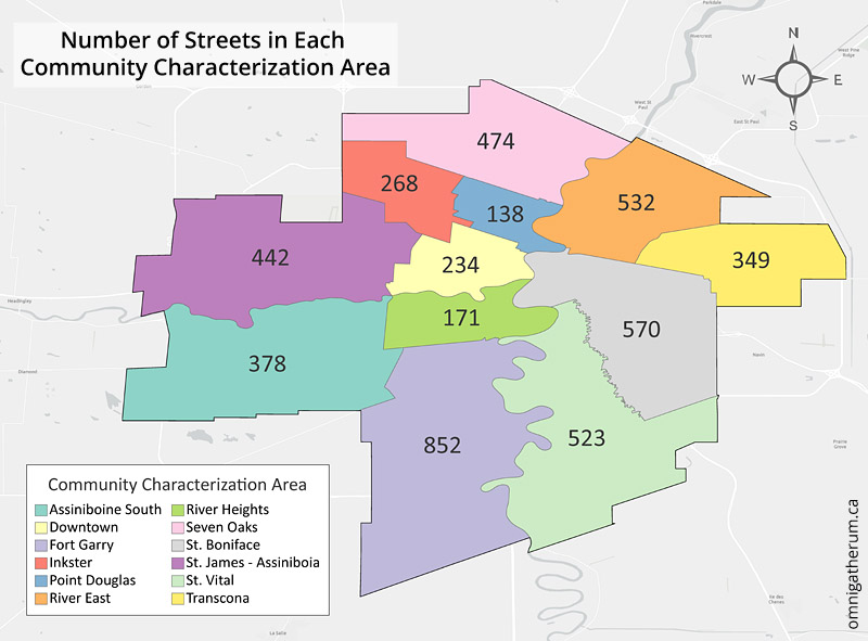
The number of streets in each Community Characterization Area (CCA) – some overlap in counts occurs.
This question could be re-phrased as “how many unique street names are there?”, as an underlying assumption is that street names in Winnipeg are unique. Given that assumption, there are in total 4,729 streets in Winnipeg.
In comparison, New York City, New York, USA, has 10,522 streets (City of New York, 2020), Los Angeles, California, USA, has 11,096 streets (City of Los Angeles, 2020), Chicago, Illinois, USA, has 2,077 (City of Chicago, 2017), and Paris, France, has 6,513 (Ville de Paris – Direction de l’Urbanisme, 2020).
Total length of all roads in Winnipeg
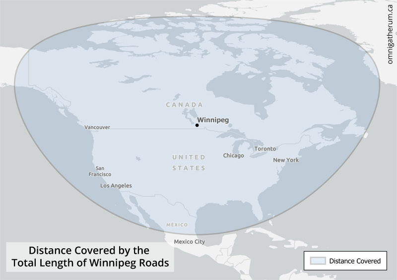
The distance covered by the total length of Winnipeg roads.
There are few different ways this question could be answered.
A City of Winnipeg Public Works web page states that there are: “1720 lane-kilometers of Regional streets, 5030 lane-kilometers of Local and Collector streets, 900 lane-kilometers of alleys” (2020c, para. 1). (NB: A kilometer of road with two lanes is 2 lane-kilometers.) On the other hand, a City of Winnipeg infrastructure report stated that Winnipeg has 1,939 lane-kilometers of regional streets and 5,396 lane-kilometers of local streets, which excludes alleys (2018b, p. 6). This would indicate that the streets of Winnipeg have a total length of between 6,750,000 lane-meters and 7,335,000 lane-meters (excluding alleys).
Adding up the length of all streets in the dataset, which does not consider lanes, results in an answer of 3,164,107 meters. The mean street length is 669 meters and the median length is 345 meters. However, as an example, this does include streets that do not technically exist (e.g. Moody Street; see “Shortest street” above). Thus, the answer is not completely accurate.
As an approximate comparison, Canada as a whole has about 1,126,000,000 two–lane equivalent meters of public roads (Statistics Canada, 2019b, p. 99). Of that, Manitoba represents 7.8% (or 87,800,000 two–lane equivalent meters). Despite being 3.78% of the land area of Canada, Japan has 1,222,319,000 meters of public roads (Ministry of Land, Infrastructure, Transport and Tourism – Road Bureau, 2018, p. 3).
Street with the highest mean value of residences
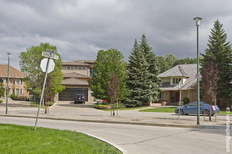
Kerslake Place, the street with the highest mean assessed value (of residences) in Winnipeg.
The definition of a home used here is one whose property use code (PUC) was one of the following:
- RESDU – DUPLEX
- RESMC – MULTIFAMILY CONVERSION
- RESRH – ROW HOUSING
- RESSD – DETACHED SINGLE DWELLING
- RESSS – SIDE BY SIDE
- RESTR – TRIPLEX
As could be expected, streets vary in the number of homes associated with them. To balance out that effect, several thresholds were examined. The values used here are the assessed values, from the parcel dataset. The results were the following:
| Threshold | Street | Mean | Count | Minimum | Maximum |
|---|---|---|---|---|---|
| 1 | Palk Road | 1,067,000 | 1 | 1,067,000 | 1,067,000 |
| > 5 | Kerslake Place | 1,362,000 | 6 | 821,000 | 3,174,000 |
| > 10 | Rose Lake Court | 1,209,285 | 21 | 870,000 | 1,417,000 |
| > 25 | Handsart Boulevard | 1,121,568 | 44 | 420,000 | 3,330,000 |
| > 100 | Park Boulevard | 1,070,280 | 139 | 479,000 | 4,753,000 |
| > 200 | Wellington Crescent | 807,133 | 233 | 241,000 | 2,800,000 |
*The values of several homes on Wellington Crescent are not available.
Though not a direct comparison, what may be the most exclusive street in the world is that of 57th Street, in the Manhattan borough of New York City, New York, USA (Warren, 2020, para. 3). 57th Street, which is considered as part of a “mini-neighbourhood” called Billionaires’ Row, has seen an average real estate sale value of $38.5 million USD since 2015 (Warren, 2020, para. 4).
Street with the highest total value of property
Portage Ave, the street with the highest total combined assessed value.
The street for which the total combined assessed values of all addresses is the highest is Portage Avenue, at $2,691,032,000. The total number of addresses is 529. If the addresses from Portage Avenue East are excluded (removing 8 addresses), the total combined assessed values of all addresses on Portage Avenue is $2,666,321,000.
This sum is greatly increased by the presence of Polo Park shopping mall (CF [Cadillac Fairview] Polo Park) which, at an assessed value of $691,663,000, is the highest value property in Winnipeg. In comparison to other large malls, this is a relative bargain. As an example, West Edmonton Mall is currently assessed at a value of $1,266,911,500 (City of Edmonton, 2020).
Portage Avenue was named in 1880; Rudnyckyj writes of it: “According to Hislop, ‘Portage Avenue is said to be the longest street in the world, having a well defined tract of over 800 miles, being the oldest trail to Edmonton'” (Rudnyckyj, 1974, p. 245). According to the Manitoba Historical Society, however, Portage Avenue was named for the fact that “it was the road to the town of Portage la Prairie, west of Winnipeg” (Goldsborough & Kramer, 2020).
References
BBC News. (2006, November 1). Street measures up to new record. Retrieved from http://news.bbc.co.uk/2/hi/uk_news/scotland/highlands_and_islands/6101968.stm
CBC News. (2015, March 4). No street names, but Street View for Sanikiluaq, Nunavut. Retrieved from https://www.cbc.ca/news/canada/north/no-street-names-but-street-view-for-sanikiluaq-nunavut-1.2981217
City of Chicago. (July 11, 2017). Street center lines [ESRI Shapefile]. Retrieved from https://data.cityofchicago.org/Transportation/Street-Center-Lines/6imu-meau
City of Edmonton. (2020). Property assessment data (current calendar year) [CSV]. Retrieved from https://data.edmonton.ca/City-Administration/Property-Assessment-Data-Current-Calendar-Year-/q7d6-ambg
City of New York. (September 3, 2020). NYC street centerline (CSCL) [ESRI Shapefile]. Retrieved from https://data.cityofnewyork.us/City-Government/NYC-Street-Centerline-CSCL-/exjm-f27b
City of Winnipeg. (2007, October 24). Council regular meeting minutes. Retrieved from http://clkapps.winnipeg.ca/DMIS/ViewPdf.asp?SectionId=196763
City of Winnipeg. (2018a, March 6). Street naming. Retrieved from https://www.winnipeg.ca/ppd/LandDevelopment/StreetNaming.stm
City of Winnipeg. (2018b). 2018 State of the infrastructure report. Retrieved from https://www.winnipeg.ca/infrastructure/pdfs/State-of-Infrastructure-Report-2018.pdf
City of Winnipeg. (2020a). Road network [ESRI Shapefile]. Retrieved April 12, 2020, from https://data.winnipeg.ca/City-Planning/Road-Network/2eba-wm4h
City of Winnipeg. (2020b). Map of assessment parcels [ESRI Shapefile]. Retrieved April 12, 2020, from https://data.winnipeg.ca/Assessment-Taxation-Corporate/Map-of-Assessment-Parcels/rt7t-3m4mOpens in new window.
City of Winnipeg. (2020c, February 7). Transportation. Retrieved from https://winnipeg.ca/publicworks/trafficControl/default.stm
City of Los Angeles. (September 4, 2020). Street centerline [ESRI Shapefile]. Retrieved from https://data.lacity.org/A-Livable-and-Sustainable-City/Street-Centerline/7j4e-nn4z
Davies, J. (2019, February 7). Meet biotechnological entrepreneur, Bert Friesen. Retrieved from https://www.sci.umanitoba.ca/chemistry/news-and-events/news/meet-biotechnological-entrepreneur-bert-friesen-bsc-hons-69-msc-71-phd-81-who-helped-eliminate-rh-disease
Glenday, C. (2008). Guinness world records 2008. New York, NY: Bantam Books.
Goldsborough, G., & Kramer, N. (2020, May 5). History in Winnipeg streets. Retrieved from http://www.mhs.mb.ca/docs/winnipegstreets/index.shtml
Johnson, M. (2009, August 7). Washington’s systemic streets. Retrieved from https://ggwash.org/view/2530/washingtons-systemic-streets
Leroux, C., & Reardon, P. T. (2008, July 27). Taking city’s pulse on a 24-mile artery. Retrieved from https://www.chicagotribune.com/news/ct-xpm-2008-07-27-0807260719-story.html.
Mason, C. (2005, November 24). The world’s longest street name. Retrieved from http://thelongestlistofthelongeststuffatthelongestdomainnameatlonglast.com/long187.html
Ministry of Land, Infrastructure, Transport and Tourism – Road Bureau. (2018). Roads in Japan 2018. Retrieved from https://www.mlit.go.jp/road/road_e/pdf/ROAD2018web.pdf
Perra, M. (2011, April 14). The ‘myth’ of Yonge Street being the world’s longest road lives on. Retrieved from https://ca.news.yahoo.com/blogs/dailybrew/myth-yonge-street-being-world-longest-road-lives-20110414-124435-380.html
Portal Płock. (2017, July 14). Radna: Mieszkańcy nie chcą nowej nazwy ulicy. Jest za długa. Retrieved from https://portalplock.pl/pl/11_wiadomosci/15989_radna-mieszkancy-nie-chca-nowej-nazwy-ulicy-jest-za-dluga.html
Reincke, M. (2013). Schottland. Germany: Baedeker.
Rudnyckyj, J. B. (1974). Mosaic of Winnipeg street names. Winnipeg, Manitoba: Canadian Institute of Onomastic Sciences.
Statistics Canada. (2019a, November 13). Road network file, reference guide, 2019. Retrieved from https://www150.statcan.gc.ca/n1/en/pub/92-500-g/92-500-g2019001-eng.pdf
Statistics Canada. (2019b). Transportation in Canada 2019 – Statistical addendum. Ottawa, Canada: Statistics Canada.
Ville de Paris – Direction de l’Urbanisme. (September 6, 2020). Linéaires des voies [ESRI Shapefile]. Retrieved from https://opendata.paris.fr/explore/dataset/voie/information/
Warren, K. (2020, January 8). The 10 most expensive streets in the world, ranked. Retrieved from https://www.businessinsider.com/most-expensive-streets-in-the-world-2019-12
Young, M. C. (1998). Guinness book of world records 1998. New York, NY: Bantam Books.